
Marc Goldman is the Director of AEC Industry Solutions at Esri. He works with the global team to define and deliver the strategy for Esri’s solutions, which serve architecture, engineering, construction, and environmental consulting. He is a leading expert in BIM, GIS, Digital Twins, and their impact on the industry. Marc began his career in the first days of CAD, he led some of the earliest BIM efforts, and he has contributed over thirty years defining, developing, and delivering services and technologies for design, engineering, manufacturing, and construction.
He works with an international network of AEC executives creating joint ventures, partnerships, and customer relationships. He is the Vice Chair of the NIBS Digital Twin Integration Subcommittee, the co-Chair of the Digital Twin Consortium AECO group, and supports buildingSMART International on the Steering Committee for the Infrastructure Domain, the OGC+bSI Working Group, and the cross-industry efforts.
The Generational Shift
Marc is invigorated by the generational shifts reshaping the built environment. As baby boomers retire, millennials, who have grown up with technology at their fingertips, are entering the industry. This new generation is driving a change in mindset, moving away from manual methods and embracing digital solutions. "The acceptance of manual methods and errors from illegible handwriting are all but gone away," Marc notes.
“Embracing technologies across the board is as high as I've ever seen it," he says with great pride.
Marc's journey in the AEC industry began at Tulane University, where he studied architecture and engineering. However, his fascination with technology started even earlier, during his high school years, when he explored the nascent world of Computer-Aided Design (CAD). His career path took a pivotal turn during the dot-com boom, a period marked by rapid technological innovation. Goldman recalls, "I was involved at Autodesk when tech was seen as a game-changer, and later when it was merely a challenge."
Historically, the AEC industry has been slow to adopt new technologies, often clinging to traditional methods – from the way information is created to the way it is shared and used to deliver projects effectively. Marc describes this as being "tech-shamed," with the industry ranking low in technology adoption. Thankfully, this is changing rapidly.
"I'm excited about the pace and the interest in technology," he says. "You name the technology, there's interest in it right now."
A Personal Turning Point
Reflecting on his career, Marc identifies a pivotal moment when he was still in architecture school. A conversation with a friend who had a degree in architecture and construction management sparked an idea that would change his trajectory. They envisioned integrating building product information with CAD, allowing designers to select materials from libraries during the drafting process. This idea led Marc to leave school and start his first business at the age of 21.
We laughed together at how crazy that was!
But then again, it was a bold move that required a leap of faith when he didn’t know what he didn’t know. A moment to follow his instincts and learn his way into an entrepreneurial role.

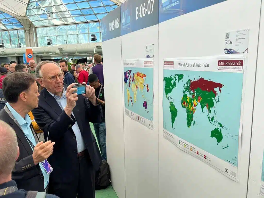
Esri User Conference. Image credit: Esri
Navigating Technological Integration
For industry leaders, the challenge lies in integrating new technologies seamlessly into existing workflows. Marc emphasises the importance of strategic implementation, where technology serves as an enabler rather than a disruptor. "It's not just about adopting the latest tech," he advises. "It's about understanding how it fits into your business model and enhances your operations."
Data, not just documents, is becoming a critical asset in the AEC industry, with its potential to drive decision-making and optimise processes. Marc highlights the increasing reliance on data analytics to improve project outcomes. "Accessible data, much better than a folder of digital documents, allows AEC teams to predict issues before they arise and make informed decisions," he explains. "It's a game-changer in terms of collaboration, efficiency and cost-effectiveness."
As environmental concerns grow, there must be a push towards sustainable building practices and material selection. Marc observes, "Sustainability is no longer a niche consideration; it's becoming a core component of project planning and execution." He goes on to explain how companies responding to decarbonisation mandates and sustainability goals require an industry organised around data, not just documents.
For leaders looking to propel their businesses forward, Marc advises, "Stay informed about technological advancements and be open to change. Invest in training and development to ensure your team is equipped to leverage new tools effectively." Otherwise, you’ll get left behind.
Collaboration and Connectivity
Another welcome trend influencing the industry is the emphasis on collaboration and connectivity.
With the rise of cloud-based platforms, teams can work together more effectively, regardless of location. Marc notes, "The ability to collaborate in real-time across different geographies is transforming how projects are managed and executed."
Creating a culture that encourages innovation and experimentation is crucial. Especially when you can access talent from across the globe and enable teams to work closely, despite not having met in person.
Marc advocates the importance of fostering an environment where team members feel empowered to explore new ideas. "Innovation thrives in a culture that values creativity and encourages risk-taking – fail+fast+forward," he recounts from Carol Bartz, the CEO at Autodesk.
He cites a significant shift in the AEC industry was marked by the unexpected collaboration between Autodesk and Esri - two companies that had previously been fierce competitors in the digital-mapping arena.
In 2017, the CEOs of both companies surprised many by announcing a strategic partnership during the annual Autodesk University conference. Marc describes this moment as akin to “two puzzle pieces fitting together to complete the bigger picture” enabled by data exchange and idea exploration.
This alliance has since evolved into a robust collaboration, with teams from both companies working together to integrate GIS, CAD, BIM, construction management, and reality capture technologies. This partnership represents a major turning point, particularly for Esri, which established a dedicated AEC, where Marc leads the Industry Solutions team, in part to maximise the alliance's potential.
This concept of forming strategic alliances - even with one of your direct competitors - might sound fanciful in the competitive world of architecture, engineering and construction, but you only need to look at how this has powered a company such as Esri and Autodesk to new heights.
Where could new strategic alliances be created across the industry to benefit practices and built environment outcomes?


Masdar City Masterplan by Foster + Partners. Image credit: Foster + Partners.
The Power of Context
Marc emphasises the critical role of context in the AEC industry, underscoring how the integration of GIS technology enhances decision-making. With accurate data collection tools (GPS in your pocket) now commonplace in everyday life, the expectation for precise location data has permeated professional settings. On job sites, questions about material placement, project issues, and site mobilisation are increasingly addressed through location-enabled insights. GIS technology allows for a deeper understanding of context, enabling professionals to navigate complex environments with ease.
This extends beyond mere location data, incorporating temporal elements specific to time as crucial additional layers for comprehensive planning.
Marc highlights how GIS facilitates the exploration of "what if" scenarios, integrating past, present, and future data. This capability is particularly valuable for addressing challenges such as demographic shifts, evolving climate change conditions, and new infrastructure development. By layering various data sets, GIS provides a multidimensional view that traditional CAD or BIM tools cannot offer.
Scenario Planning and Future Projections
Marc recalls an interview during the COVID-19 pandemic where he was asked about the role of GIS in the AEC industry. He insisted that context, including projections and historical data, is indispensable. It uniquely enables professionals to visualise and analyse different complex scenarios over time, supporting more informed decision-making and strategic planning.
This is a holistic approach to planning and design - and it allows design teams to involve stakeholders more effectively in the decision-making process.
Location-aware, evidence-based design is increasingly what clients are expecting.
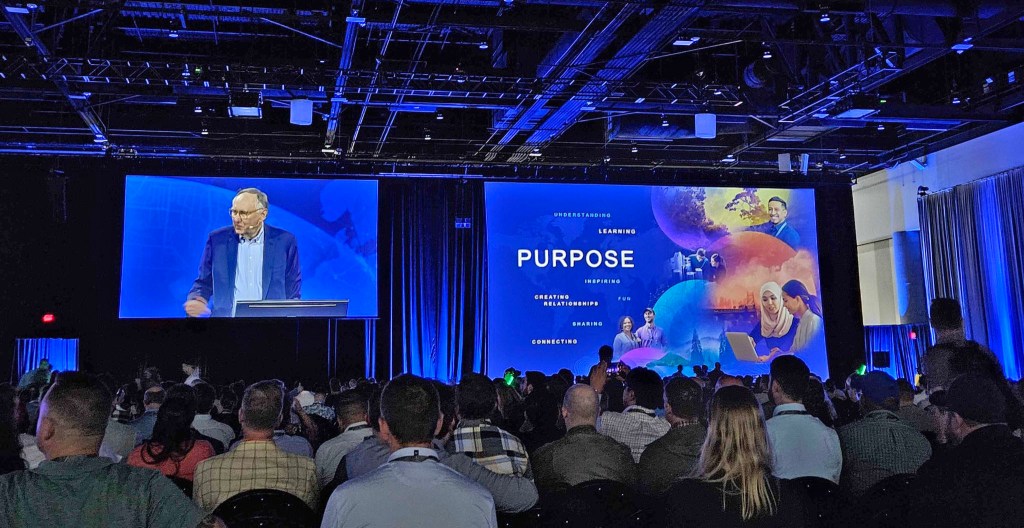
Marc describes a presentation by Foster and Partners, a UK-based architecture firm, at Esri's User Conference. They utilised GIS tools and spatial analytics to analyse urban patterns in cities like London, Paris, and New York to generate an informed design for a new city in the Middle East.
This data-driven approach enabled them to deliver more comprehensive proposals in less time compared to traditional methods.
It’s probably no surprise that the effectiveness of GIS systems hinges on the quality of data input. This data encompasses everything from street locations to demographic shifts, providing a foundation for evidence-based design. Integrating various data types, such as traffic patterns and weather conditions, is facilitated by the common denominator of geographic coordinates. GIS technology also incorporates advanced methods like artificial intelligence and machine learning to project future scenarios, offering a robust platform for strategic urban planning.
With the added advantage that practices can apply their proprietary data research to these models - promoting unique points of difference and expertise.
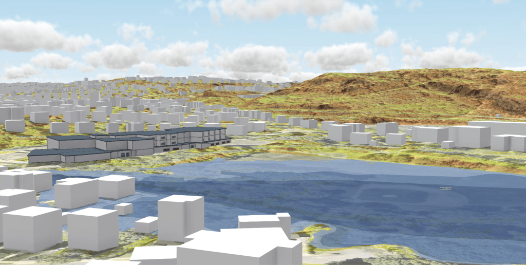

GIS BIM with flood data terrain model satellite imagery and road data for elementary school planning. Image credit: Esri
Tuning the Data
The question of who owns city-based information (to support an evidence-based approach) is complex, involving a mix of public and private entities.
Utilities, city governments, engineering firms, and commercial satellite operators all contribute to the data landscape. Marc reveals that Esri utilises a hybrid environment where data is curated locally, publicly, privately, and accessed through platforms like The Living Atlas of the World. This resource provides thousands of data layers and deep learning models, enabling users to analyse everything from car counts to wildlife encroachment.
The management of city information varies by location. As an example, he recalls discussing Singapore's digital twin initiatives which aim to create a comprehensive digital representation of the city, with separate access levels for public and private use. Such initiatives highlight the balance between security and the need for accessible information. Cities often share non-proprietary data, such as tree inventories and points of interest, through platforms like Living Atlas, and share engineering-grade survey data by request only, contributing to a global pool of valuable resources.
Fostering Collaboration
Collaboration is key to overcoming the challenges of siloed thinking and competitive isolation. Marc emphasises the importance of interoperability in fostering this adoption, noting that while companies can maintain their unique selling propositions (USPs), they must also ensure that their solutions can integrate seamlessly with others.
This is exemplified by the unusual partnership between Autodesk and Esri, which demonstrates how former competitors can join forces for mutual benefit. By sharing data and capabilities through Application Programming Interfaces (APIs) and supporting industry standards like those from buildingSMART International, companies can enhance their offerings while contributing to a more interconnected industry.
Stop and think about how strategic collaboration leading to new alliances being formed could unlock innovation, new business models and potentially new markets.
Marc highlights the significance of industry standards, such as the Industry Foundation Classes (IFC) and the buildingSMART Data Dictionary (bSDD), in enabling interoperability. These standards facilitate the exchange of information across different platforms, ensuring that data can be used effectively throughout a project's lifecycle.
By adhering to these standards, companies can collaborate more efficiently improving project outcomes. Partnerships with a range of stakeholders, from engineering firms to software providers, further enhance the ability to support the entire project lifecycle, from planning to operation.
Empowering Smaller Practices
Interoperability and strategic collaboration also open up opportunities for smaller practices to participate in large-scale projects.
By combining forces and leveraging shared data, smaller firms can compete with larger entities, bringing diverse problem-solving capabilities to the table. This collaborative approach not only democratises access to major projects but also encourages innovation by allowing a wider range of perspectives and expertise to contribute to project success.
Marc advocates that by focusing on data rather than file-based systems, companies can ensure that information flows seamlessly across different applications and platforms. This supports real-time collaboration and decision-making, enhancing the efficiency and effectiveness of project management. The integration of facilities management technologies such as Internet of Things (IoT) sensors, further extends the remit of operational practices to manage and maintain facilities with greater precision and insight.
Encouraging collaboration involves not only technological integration but also a cultural shift towards openness and information sharing. Creating an environment where companies can share data and insights while protecting their core USPs is where we will see the industry achieve greater innovation and efficiency. This ethos is essential for addressing the complex challenges of modern construction and ensuring the industry's continued growth and success.
Lowering Barriers to GIS Adoption
Marc highlights the barriers to entry for accessing GIS technologies for mid-size and smaller practices are now quite low. He suggests that anyone using CAD or BIM applications should also consider having GIS software, such as ArcGIS Pro or ArcGIS Online. The technology is becoming less complex and more user-friendly compared to just a few years ago. This evolution allows even small organisations, like independent hospitals, to utilise GIS for tasks such as space planning, which were once thought to be the domain of large campuses.
Today, users can explore and utilise these tools with minimal formal training, creating maps and integrating various data sources, including CAD, BIM, drone images, and IoT sensor data. This ease of use extends to producing visualisations and analyses that can be shared with different audiences, from internal teams to the general public, with varying levels of access and context. The technology's flexibility allows for dynamic changes in perspective and focus, making it a powerful tool for planning and decision-making.
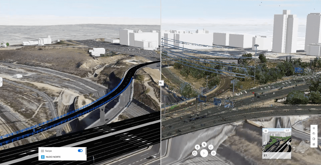
OHLA GIS BIM for infrastructure Madrid is interoperable based on buildingSMART open standards. Image credit: Esri
Digital Twins and Real-Time Data Integration
The push towards digital twins is a significant driver in making information more accessible and actionable. Marc envisions a future where individuals can easily access comprehensive data about their cities and communities, aiding in productivity and planning. Whether it's determining the best location for a community centre or assessing road conditions after a storm, GIS technology facilitates real-time connections between the physical and virtual worlds.
Marc emphasises that while not everyone is an engineer capable of interpreting complex data, GIS technology empowers users to interact with maps and data layers intuitively. This democratisation of data access allows individuals to gain insights without needing specialised training. By simply interacting with a map, users can obtain valuable information about their environment, making it a vital tool for both professionals and the general public.
As digital twin rendition continues to advance, Marc predicts that interacting with digital representations of our physical world will become as commonplace as browsing the internet for a restaurant menu.
This immersive interaction will not require specialised equipment like headsets but will be integrated into everyday experiences, offering a seamless way to understand and engage with the world around us.
“The convergence of GIS, digital twins, and real-time data is poised to transform how we perceive and interact with our environments.”
Marc acknowledges the investment Esri makes in research and development. With around 5,000 employees and a global presence, Esri may not be the largest technology company, but it prides itself on being one of the most impactful. The company engages with its 3000 partners and its 10 million users through various channels, including user conferences, to gather feedback and identify new areas for R&D. This approach allows Esri to remain agile and responsive to the needs of its diverse user base, which ranges from individual desktop users to entire city governments, and larger.
Building an Ecosystem for Innovation
Marc draws parallels between Esri and Autodesk, highlighting the importance of creating an ecosystem that supports innovation.
Rather than chasing every potential revenue stream, Esri focuses on extending its platform to allow partners to develop specific solutions for various industries. This strategy not only fosters innovation but also enables Esri to concentrate on broader, more impactful projects. The company supports a wide array of sectors, including government, retail, conservation, and utilities, by providing both specific solutions and a flexible platform for partner-driven innovation.
Marc notes a trend among engineering and consulting firms that began by using Esri software for specific projects and eventually led to the development of repeatable solutions. These firms transition from project-based work with thin margins to becoming software developers with more predictable revenue models. An example is a firm in Jacksonville, Florida, which created a solution for digital twin development and now sells it to other engineering firms across the country. This shift not only enhances profitability but also allows firms to expand their influence beyond their immediate geographic area.
Pause and think about what in-house capabilities you have been developing within your practice that could follow this entrepreneurial business model.
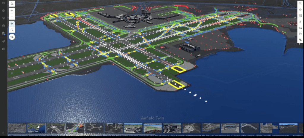
GIS BIM Airfield Twin component of the entire SFO Airport Twin. Image credit: Esri
Advancements in Digital Twins
The evolution of 3D modelling and digital twins has been remarkable, with companies now able to produce centimetre-accurate data-rich 3D models of cities. This capability is transforming how businesses and governments approach urban planning and infrastructure management.
Marc believes digital twins are already all around us at various levels of maturity and impact; he pictures a future where digital twins become integral to understanding and managing our physical world.
As technology advances, the integration of real-time data and immersive 3D models will enhance our ability to plan and respond to urban challenges. The development of digital twins, supported by GIS, offers a powerful tool for visualising complex systems in context, leading to more informed decisions. This approach not only improves operational efficiency but also supports sustainability efforts and enhances public engagement through interactive and accessible platforms.
Gone are the days when a stack of blueprints or a few 3D views sufficed for project presentations.
Today, there is an expectation for comprehensive information sharing and active stakeholder involvement throughout the design and construction process. The location-based foundation of GIS provides a unique platform for this, enabling the integration of spatial analytics and multiple data layers into interactive maps and visualisations. These tools not only improve building designs and sustainability but also facilitate collaboration by allowing stakeholders to engage directly with the data.
Marc shares an example of how this has been used at San Francisco International Airport, which has digitised its entire facility using GIS. This comprehensive digital model includes every utility and building in both 2D and 3D, allowing for seamless integration and management across various departments. The GIS system supports a wide range of operations, from security and runway management to space planning and Federal Aviation Administration (FAA) compliance. By normalising information and making it accessible to all team members, regardless of their technical expertise, the airport has significantly enhanced its operational efficiency and safety.
Empowering Decision-Makers
Marc asserts that GIS technology empowers decision-makers by providing them with detailed, real-time information. He describes for instance, a city mayor can use GIS to make informed decisions about urban development, choosing between investing in downtown projects or addressing suburban sprawl. The ability to share interactive maps with stakeholders, such as residents curious about local construction projects, further democratises access to information and enhances public engagement.
The goal is to ensure user-friendly interfaces and the ability to integrate various data types so that GIS tools are no longer perceived as complex or exclusive to large organisations.
He suggests, "GIS had a perception of being difficult software to use and maybe it was at one point. But I find myself, an untrained user, opening up our software and creating some amazing maps in 2D and 3D that are more compelling and complete than the CAD, BIM, 3D animation and web development work I used to do, which required tons of training and years of expertise."
The Future is Bright
The push towards digital twins and immersive experiences is paving the way for more sophisticated and context-aware planning and design processes.
By integrating GIS with other technologies like BIM, stakeholders can visualise complex scenarios, optimise site selection, and improve asset management. This integration not only enhances project outcomes but also supports sustainability and resilience in urban development. As the industry moves towards a more data-driven approach, GIS will continue to play a critical role.
"The pace of innovation around imagery... has been phenomenal. There is an industry of companies flying satellites around the planet, or planes over major cities and their cameras are generating images at multiple angles delivering 3D models at amazing levels of accuracy."
Marc highlights the progressive use of GIS in construction design management, particularly by firms like Skanska UK. By integrating CAD, BIM, GIS, and field-based data collection, these firms create comprehensive dashboards that streamline project management. This integration allows field workers to report issues such as water hazards or old construction components directly onto a 3D map, enhancing communication and efficiency. The collaborative nature of GIS enables teams to quickly transition from design to construction, leveraging various data types to provide a unified view of project conditions and requirements.
GIS has become a pervasive capability across industries, with most cities and governments utilising it in some form. The technology is increasingly approachable, both in terms of cost and ease of use. Many professionals entering the workforce already possess some GIS knowledge, making it easier for companies to integrate GIS into their operations.
Digital twins are becoming essential for understanding and managing infrastructure and urban development. GIS provides the geospatial data and analysis capabilities necessary for creating accurate and dynamic digital twins. This integration supports a wide range of applications, from infrastructure projects to disaster response.
Marc envisions a bright future for GIS, with growth outpacing the majority of AEC industry technologies.
Key Takeaways
Driven by a generational shift eager to enhance efficiency and creativity, Marc Goldman's insights provide a roadmap for how to embrace an evidence-based design approach to improve the quality of our built environments. He advocates for leveraging GIS technology to level the playing field amongst practices, make more informed decisions quickly and hone in on your unique value proposition.
Marc emphasises the importance of seeking strategic alliances and collaboration partners to innovate with greater impact.
He prompts, "We're at a point where a digital twin of our entire physical world is going to be something that we interact with on a pretty regular basis." Integrating GIS is revolutionising urban planning, offering detailed, real-time insights that improve stakeholder engagement as well as operational efficiency and sustainability.
The future of GIS is bright, especially with its foundational role in emerging technologies like IoT and digital twins promising continued growth and innovation. He urges us to ride the wave of youthful technological uptake and see where it takes us.